Global Distributors Wanted
1.Free Cloud Service Deployment
2.Free Technical Training
3.Exclusive Territory Protection

1.Free Cloud Service Deployment
2.Free Technical Training
3.Exclusive Territory Protection


Views: 212 Author: Aaron Publish Time: 2026-10-17 Origin: Site


Content Menu
● Drone Food Delivery vs E-Bike Delivery: Key Differences
● Delivery Speed: Compare the Whole Journey
>> Why Drones Can Win Across Water
>> Why E-Bikes Can Still Arrive First
● A Practical Cross-Waterfront Route Calculation
● Cost per Delivery: What Operators Should Count
>> Drone Delivery Costs Extend Beyond Electricity
>> E-Bike Economics Depend on Productivity
● Food Quality, Payload, and Customer Convenience
>> Match the Meal to the Delivery System
>> Collection Lockers Are Not Doorstep Delivery
● Waterfront Safety, Weather, and Operating Permission
>> Water Crossings Need Specific Risk Planning
>> Permission Is Route- and Jurisdiction-Specific
● Environmental Performance: Neither Mode Is Automatically Greener
● Industry Case: Shenzhen Bay Park
● Why Coordinated Drone and E-Bike Delivery Deserves Attention
● A Five-Step Pilot for Waterfront Delivery Buyers
>> 1. Establish the E-Bike Baseline
>> 2. Confirm Route and Endpoint Feasibility
● Build the Route Around the Service Promise
>> 1. Is drone food delivery always faster than e-bike delivery?
>> 2. Which option is cheaper for waterfront food delivery?
>> 3. Can delivery drones fly directly across any river or bay?
>> 4. Are e-bikes better for large food orders?
>> 5. Does drone delivery reduce emissions?
>> 6. What should happen when drone operations are suspended?
Drone food delivery can outperform e-bike delivery on cross-waterfront urban routes when an approved flight corridor bypasses a long bridge detour. E-bikes remain more practical for flexible doorstep service, larger orders, and neighborhoods with efficient cycling connections. The strongest solution is often hybrid: drones handle the difficult crossing, while ground couriers complete local distribution.
For restaurant groups, delivery platforms, and waterfront developers, the question is not which vehicle looks more advanced. It is which operating model delivers meals reliably, protects food quality, and makes financial sense.
My assessment starts with the complete customer journey—not the aircraft's advertised speed. Restaurant preparation, loading, customer collection, and weather-related interruptions all influence whether a faster crossing becomes a better service.

Cross-waterfront delivery connects destinations separated by rivers, bays, canals, or harbor infrastructure. These routes can create a mismatch between geographical proximity and practical accessibility.
A restaurant may sit directly opposite a waterfront community, yet the nearest usable bridge requires a substantial detour. Conversely, a dedicated cycling bridge can make an e-bike highly competitive.
| Decision factor | Drone food delivery | E-bike delivery |
|---|---|---|
| Route geometry | Can bypass water where flight is authorized | Depends on bridges and permitted ground connections |
| Delivery endpoint | Usually requires an approved handover arrangement | Often supports direct building access |
| Order suitability | Constrained by aircraft payload and packaging | More flexible for mixed and bulky orders |
| Infrastructure | Needs launch, receiving, charging, and control arrangements | Needs charging, parking, and courier access |
| Weather exposure | Subject to aircraft-specific operating limits | Also affected by hazardous weather and surface conditions |
| Best application | Repeated, time-sensitive crossings | Flexible neighborhood distribution |
Neither mode wins everywhere. Route geometry, demand concentration, and endpoint design determine the result.
A drone's principal advantage is avoiding ground-network detours.
However, the relevant distance is the approved flight path—not a straight line drawn across a map. Airspace restrictions, waterfront activity, sensitive sites, and safe operating procedures may alter the route.
Where a usable aerial corridor is much shorter than the cycling route, drone food delivery can offer a meaningful advantage.
E-bikes can eliminate intermediate transfers. A courier may collect directly from a restaurant and travel to the customer's building without passing through a separate launch station or collection locker.
Evaluate both modes using:
- Restaurant-ready time.
- Collection and dispatch waiting.
- Loading or transfer time.
- Actual travel time.
- Customer handover or collection time.
A drone that crosses the water quickly can still lose if the meal waits at the launch point or the customer must walk far to collect it.
Track median delivery time and the 95th percentile—the time within which 95% of deliveries finish. Consistency matters as much as a best-case demonstration.
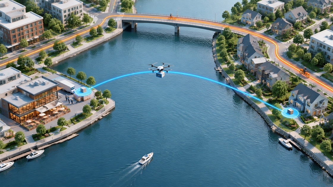
Consider an illustrative route, not a measured SIDT deployment.
Assume the approved aerial corridor is 2 kilometers, while the usable cycling route is 7 kilometers because of a bridge detour.
Using hypothetical average travel speeds of 40 km/h for the drone and 20 km/h for the e-bike:
- Drone travel takes 3 minutes.
- E-bike travel takes 21 minutes.
- The aerial leg saves 18 minutes before handling and handover.
That creates an 18-minute allowance for additional drone-related transfers before its time advantage disappears.
If loading and customer collection add 12 minutes, the drone remains faster. If they add 20 minutes, the e-bike wins.
The calculation is deliberately simple. Real assessments must include return journeys, waiting, route restrictions, charging, weather, and realistic average speeds. Its value is showing exactly where the proposed service gains—or loses—its advantage.
A credible drone delivery budget should include:
- Aircraft acquisition or leasing.
- Battery replacement and charging equipment.
- Launch and receiving infrastructure.
- Remote supervision and operating personnel.
- Maintenance, insurance, and communications.
- Required approvals and compliance.
- Failed deliveries and ground fallback.
A short flight does not automatically produce a low-cost order. Utilization determines how fixed costs spread across completed deliveries.
E-bike costs include courier compensation, vehicles, batteries, maintenance, insurance, and dispatch support.
Their economics can improve when couriers combine nearby orders. However, a long waterfront detour may reduce completed deliveries per working hour.
Compare total route operating cost divided by successfully completed orders—not electricity cost per kilometer.
Include return travel for both modes. An empty drone return and an e-bike courier's repositioning journey consume capacity even when neither carries a customer order.
A particularly useful measure is cost per on-time, successfully handed-over meal. It prevents apparently cheap but unreliable services from looking attractive.
Aircraft payload eligibility must account for the meal, drinks, protective packaging, and any carrier included in the payload calculation.
Do not choose a drone using an advertised maximum payload alone. Require validated performance for the intended package and route, including return or recovery requirements.
E-bikes generally offer more flexibility for family meals, multiple drinks, and combined orders. Nevertheless, carrying capacity depends on the vehicle and approved loading arrangement.
For either mode, test:
- Spill resistance and closure security.
- Temperature retention.
- Container stability.
- Tamper evidence.
- Condensation and food presentation.
The fastest meal is not necessarily the best-delivered meal.
A waterfront collection point can work well for parks, campuses, and managed developments. It may be less suitable for customers with limited mobility or destinations far from the receiving station.
Display the collection location and walking requirement before checkout.
A fair comparison evaluates equivalent service. Drone delivery to a locker should not be presented as identical to e-bike delivery to an apartment entrance.
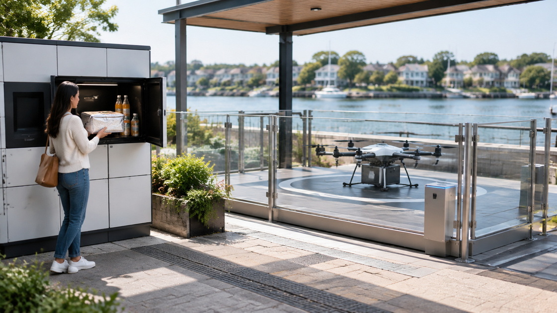
An open water surface should not be treated as automatically safe airspace.
Route assessments should consider vessels, birds, shoreline crowds, nearby aviation activity, communications coverage, and emergency procedures.
Weather limits must come from validated aircraft capabilities and operating authorization. Avoid generic claims that a delivery drone works in "all weather."
Ask suppliers to document:
- Wind and gust limits.
- Rain and temperature limits.
- Battery reserve requirements.
- Lost-link behavior.
- Emergency recovery procedures.
- Inspection requirements for waterfront exposure.
E-bikes also require clear suspension criteria for unsafe conditions. Ground fallback is useful only when the ground route remains safe and accessible.
Commercial delivery authorization does not follow automatically from buying an aircraft.
For example, the published U.S. framework requires Part 135 certification for compensated small-drone delivery beyond visual line of sight, together with relevant operational permissions.
Other jurisdictions apply different requirements. Verify the applicable rules, endpoint permissions, insurance, and operational responsibilities before promising a launch date.
Both systems use electricity, but their environmental impacts depend on more than propulsion.
Relevant variables include distance, order consolidation, aircraft size, battery replacement, electricity generation, return travel, and receiving infrastructure.
A 2025 simulation study comparing takeaway delivery systems found drone operational greenhouse gas emissions approximately 25%–54% higher than e-bike emissions in its modeled scenarios. Under selected lifecycle scenarios carrying one or two orders per flight, drones showed emissions approximately 1%–12% lower.
These are scenario-dependent results, not universal performance claims.
The practical lesson is to compare the same service boundary. Include the complete delivery chain, infrastructure energy, and successfully delivered meals.
For cross-waterfront routes, the drone's potential environmental benefit must be evaluated against the actual bridge detour—not assumed from its shorter-looking flight path.
Shenzhen Bay Park began piloting a Meituan drone food delivery service on June 1, 2024.
The reported route connected Coastal City shopping mall with North Bay Harbor, approximately 2 kilometers away. Reported delivery could take as little as 10 minutes, compared with previous waits exceeding 50 minutes around the destination.
This example demonstrates how aerial delivery can improve access to a waterfront location.
However, it does not establish a universal drone-versus-e-bike speed ratio. The published account does not isolate comparable courier travel time, and it does not prove that the flight crossed open water.
For project planning, the useful takeaway is endpoint accessibility: a drone route can help where conventional delivery reaches a destination inefficiently.
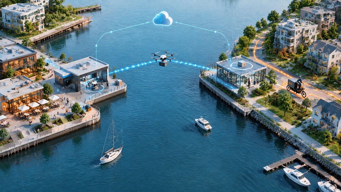
A combined network can assign each transport mode to the task it performs best.
One possible workflow is:
1. Collect meals from restaurants near the waterfront.
2. Consolidate eligible orders at a launch point.
3. Fly the approved cross-water corridor.
4. Transfer meals to a receiving station or ground courier.
5. Complete local delivery and record handover.
This model requires more coordination than operating either fleet alone. Every transfer introduces potential delay and responsibility disputes.
A unified platform should therefore track order identity, package custody, aircraft availability, weather status, receiving capacity, and fallback decisions.
Shenzhen Intelligent Drone Technology Co. Ltd. describes its "one-network coverage" approach around unified cloud-based command, dispatch, and management across multiple spaces and nodes. That company positioning is relevant to coordinated waterfront logistics.
However, buyers should verify route-specific capabilities, integrations, approvals, and service commitments. A platform description is not evidence of a completed commercial deployment.
Measure existing delivery times, costs, order sizes, failure reasons, and peak-period performance.
Separate restaurant preparation delays from transport delays.
Review the proposed flight corridor, ground route, permissions, communications, receiving space, and customer access before selecting equipment.
Set tested limits for package weight, dimensions, liquids, temperature sensitivity, and combined orders.
Publish clear rejection and fallback rules.
Evaluate similar destinations, meal types, and demand periods. Record all cancellations and fallback deliveries rather than removing inconvenient results.
Agree on measurable acceptance criteria:
- On-time delivery rate.
- Cost per successful order.
- Food damage and spill rate.
- Customer collection time.
- Weather-related service availability.
- Safety and community complaints.
Expand only when the complete service meets these criteria—not simply because the aircraft completes the crossing.
Drone food delivery suits waterfront routes where an authorized aerial corridor creates a substantial advantage. E-bikes suit flexible local access, consolidated orders, and direct handover.
For developers and delivery operators evaluating a cross-waterfront network, send SIDT your origin–destination map, hourly demand, package profiles, and target delivery times. Request a route-specific assessment covering aerial feasibility, ground coordination, receiving infrastructure, fallback operations, and measurable acceptance criteria.
No. Drones benefit when an approved aerial route avoids a substantial ground detour. Loading, transfers, and customer collection can eliminate that advantage.
It depends on utilization, staffing, infrastructure, and route productivity. Compare fully allocated cost per successful delivery rather than energy consumption alone.
No. Feasibility depends on applicable permissions, airspace, aircraft capability, local hazards, communications, and approved operating procedures.
They are often more flexible, but suitability depends on vehicle capacity and packaging. Drone orders must remain within validated payload and dimensional limits.
Not automatically. Results depend on the full delivery system, including electricity, infrastructure, return travel, and the distance avoided.
Use a predefined alternative where safe and available. Notify customers promptly and update delivery times rather than leaving orders waiting indefinitely.
1. Updated September 3, 2026. Supports the U.S. certification discussion, operational authorization requirements, environmental review, and community considerations.
2. June 3, 2024. Supports the Shenzhen Bay Park pilot date, approximately 2-kilometer route, reported 10-minute delivery, and previous waits exceeding 50 minutes.
3. 2025. Simulation-based comparison supporting the operational and lifecycle emissions figures. Its results should not be interpreted as measured performance for SIDT or all waterfront routes.
4. (00180-5. August 12, 2022. Additional research supporting the importance of delivery mode, energy sources, payload, and assessment assumptions when comparing environmental performance.00180-5)
5. February 13, 2018. Supports the need to include infrastructure and lifecycle boundaries rather than assessing aircraft electricity consumption alone.
6. Shenzhen Intelligent Drone Technology Co. Ltd. — Company background supplied for this article. Source for SIDT's stated intelligent flight platform, unified cloud control, and "one-network coverage" positioning. No public company URL was supplied.
7. Editorial analysis: the hypothetical route calculation, procurement framework, and pilot checklist are illustrative recommendations, not published trial results or independently verified SIDT performance claims.


